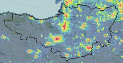
Somerset enjoys 8th darkest skies in England
The most detailed ever satellite maps of England’s light pollution and dark skies, released today by the Campaign to Protect Rural England (CPRE), have shown that Somerset has some of the best places in England for stargazing.[1]. The maps, produced using satellite images captured at 1.30 am throughout September 2015, show that…
Exmoor National Park is the second darkest place in England, having 92% pristine dark skies. Infact, Exmoor became an International Dark Sky Reserve in 2011, the first in Europe. Other areas of Somerset, including the Levels and Moors also enjoy dark skies and minimal light pollution, though not across such a large, unbroken area as Exmoor. Over 22% of Somerset was recorded as having the lowest band of light pollution when the mapping was done.
West Somerset District is the darkest of the five districts in Somerset and is actually the 7th darkest district out of all 326 districts in England. South Somerset is 53rd, Mendip 55th place, Taunton Deane 78th place and Sedgemoor in 91st place.
Sedgemoor’s lower ranking is due to prominent light pollution from the towns of Bridgwater, Burnham on Sea and Highbridge and shows the impact of the line of development along the M5 corridor. Taunton Deane and South Somerset districts show the same pattern with Taunton itself and Yeovil having high levels of light pollution but rural areas in these districts still remaining relatively dark. In Mendip, there is a more scattered pattern of low level light pollution even throughout more rural areas which is something that could be addressed by better design of lighting.
This research comes at a time of increasing awareness of the harmful effects light pollution can have on the health of people and wildlife. That these skies were monitored at 1.30am illustrates just how long into the night England’s lighting spills.
The new maps were produced by Land Use Consultants from data gathered by the National Oceanographic and Atmospheric Administration (NOAA) in America. The NOAA satellite captured visible and infrared imagery to determine the levels of light spilling up into British skies. CPRE is sending lesson plans to primary schools in order to promote the enjoyment of dark skies.
CPRE is calling on Somerset’s local authorities to use these maps to identify areas with severe light pollution and target action to reduce it, as well as identifying existing dark skies that need protecting. CPRE Somerset recommends that:
• District Council’s use these CPRE maps to inform decisions on local planning applications and identify individual facilities that should be asked to dim or switch off unnecessary lights.
• Local businesses review their current lighting and future development plans to save money by dimming or switching off light to reduce pollution.
Emma Marrington, senior rural policy campaigner at the Campaign to Protect Rural England (CPRE), said:
“Our view of the stars is obscured by artificial light. Many children in urban areas may not have seen the Milky Way, our own galaxy, due to the veil of light that spreads across their night skies. Our Night Blight maps show where people can expect to find a truly dark, starry sky. The benefits of dark skies, for health, education and tourism, are now being recognised” Chris Lewis, Chair of CPRE Somerset said: Dark skies are a key characteristic of what makes the countryside so different from urban areas and they offer a sense of awe and wonder to local people and to visitors lucky enough to experience them. We are really proud that Exmoor National Park is leading the way in protecting its dark skies through strong lighting policies. We hope that CPRE’s new mapping will enable other areas of Somerset to make their skies as dark as possible. Obviously this is more of a challenge in more populated areas but there are steps that all Councils can take to reduce light levels by demanding better planning and design of new developments. We would also encourage investment in the right street lighting that is used only where and when it is needed.”
Notes [1] CPRE’s interactive maps can be accessed at http://nightblight.cpre.org.uk/.
Light pollution is a generic term referring to excess artificial light that shines where it is neither wanted nor needed. In broad terms, there are three types of light pollution: • skyglow – the pink or orange glow we see for miles around towns and cities, spreading deep into the countryside, caused by a scattering of artificial light by airborne dust and water droplets • glare – the uncomfortable brightness of a light source • light intrusion – light spilling beyond the boundary of the property on which a light is located, sometimes shining through windows and curtains


